Wayland’s Smithy Long Barrow: Three Monuments Along the Same Sacred Line
Welcome back to Stone Temple Gardening, where we explore ancient monuments through landscape, movement and encounter.

This article grew from a wonderful day spent walking the Ridgeway with Hedley Thorne of the Wessex Ways podcast. Hedley guided me through the landscape with good humour, generous knowledge and a remarkable eye for landscape photography. We had admired one another’s work on social media for some time before finally meeting in person. Fittingly, it was his autumn aerial photograph of the Uffington White Horse that first brought his work to my attention. We began corresponding soon afterwards, and eventually the invitation came to explore Wayland’s Smithy, White Horse Hill and the surrounding monuments together. Where else could we have gone? You can watch us exploring Wayland's Smithy Long Barrow below.
The Ridgeway: An Ancient Routeway
We met at the Ridgeway car park near Ashbury in Oxfordshire one late-summer morning and immediately got on like a house on fire. Good conversation is a rare commodity, and I am grateful to have got to know Hedley in person.

You can follow him on X @thorneh and listen to the Wessex Ways podcast.
If, like me, you love landscape and history, you will not be disappointed.
With the pair of us talking ten to the dozen, the mile along the Ridgeway from the cars to Wayland’s Smithy seemed to pass in moments. Late-summer sunshine bathed the dry fields in gold while red kites and buzzards circled above the Vale of the White Horse, falling away below the ridge to our left. Walkers, joggers and cyclists passed us with cheery good mornings. The Ridgeway carried us all forward, as it has carried people for centuries: a living route across the downs, busy still, yet spacious enough for the eye to travel across the hazy Vale and along the folds of the land. My landscape first method is explained here.
Eastward beyond the Smithy lies Uffington Castle, the Iron Age hillfort above the older Bronze Age White Horse cut into the chalk slope. Across the wider downs lie the Bronze Age burial mounds of the Lambourn Seven Barrows. Wayland’s Smithy is older still. These places do not belong to a single period, but their repeated creation along and around the ridge gives the downs an extraordinary density of memory.The landscape was memorialised over millennia.
At the turn towards Wayland’s Smithy, the experience changes. The path enters the trees and the views close around you. Ahead, through the trunks, the façade becomes just visible: a few great stones projecting from the woodland, an ancient presence obscured by modern beeches and revealed only as you draw close.
The trees are beautiful, especially in autumn when their leaves turn golden copper in the low light. But they also conceal the monument’s original relationship within its landscape. The long barrow was built in a more open setting, its newly exposed chalk rubble potentially bright against the downs. Today, trees interrupt the view south-south-east from the entrance towards Tower Hill and the flat country beyond. The view north over the Vale is almost completely obscured. They also prevent us from judging directly how the monument related visually to White Horse Hill once inter-visible a mile east from here. Much of the surrounding horizon is now either completely screened in green or broken into small fragments between trunks and branches.
For Stone Temple Gardening, this matters. A prehistoric monument is never just the monument. Its position, approach and outlook may be as important as the stones themselves. The beeches give Wayland’s Smithy its present intimacy, but they take away much of its landscape power. To understand the place, we must try to see beyond them.

Three Monuments in One Place
Wayland’s Smithy is conventionally described as two monuments: Wayland’s Smithy I and the much larger chambered long barrow we see today called Wayland’s Smithy II. Within the earlier monument, however, excavation revealed a distinct mortuary structure that existed before the small mound covered it. I find it more revealing to follow three monumental episodes here: the construction of a place for the dead, its enclosure beneath a mound, and the creation of a new chambered monument around and over that inherited place.

This was not a slow transformation spread evenly across many centuries. The radiocarbon reassessment published by Alasdair Whittle, Alex Bayliss and Michael Wysocki in 2007 suggests a more compressed and uneven history. Initial deposition probably began around 3590–3555 BC. The small mound was probably built around 3520–3470 BC, followed by the larger long barrow around 3460–3400 BC. These are probability ranges rather than exact construction dates. The account that follows uses the researchers’ preferred model; they also considered an alternative in which the later chambers were constructed earlier in the sequence. I have written about other long barrows in general here,and here.
I have also written about the near contemporay longbarrow at West Kennet in Avebury here.
The First Mortuary Site
The earliest structure combined timber with stone. A sarsen pavement, approximately 16 feet (4.9 metres) long and around 5 feet (1.5 metres) wide, lay between two substantial D-shaped post pits with the flat sides facing each other. The exact form of the structure above it remains uncertain. Atkinson envisaged a pitched, tent-like construction; later interpretation favoured a lower, box-like structure with a lid or covering. Both reconstructions try to explain an architecture that has vanished, leaving its foundations and contents beneath the later mound.

Fourteen people were represented in the mortuary deposits: eleven males, two females and a child. Most of the remains lay slightly north of the centre of the paved area, while its southern half was empty. At the northern end was a separate articulated crouched burial, with the skull towards the south and the lower body close to the northern post position. This was not an undifferentiated scatter of bones. Bodies and remains occupied particular parts of a deliberately constructed space.
Timothy Darville makes an interesting symbolic comment in his Long Barrows of the Cotswolds book that as the dead were framed between the two D shaped posts, probably a split tree trunk,
“In this respect, the dead lay within a tree…”
Several of the bodies appear to have been introduced as fleshed or partly decomposed. Other bones were disarticulated or displaced, with evidence of scavenging as well as disturbance associated with successive deposition. We should not imagine either a neatly ordered collection of dry ancestral bones or a single burial event. The mortuary space had a short but complicated history. The preferred dating model suggests that its deposits may have accumulated in only one to fifteen years.
There is also a sharper human story within the bones. An arrowhead tip remained embedded in a male pelvis, with no sign of healing. Whatever else this place was or became, it received at least one person injured by an arrow at or around the time of death. The arrowheads associated with the deposits cannot all be comfortably described as offerings.
So it is reasonable to propose that this was a site of ritual encounter in a practical as well as an interpretative sense. People brought bodies or remains here, approached its timber and stone boundaries, and placed the dead within them. How often they subsequently handled or rearranged those remains is harder to establish, but the structure initially allowed access. Before the mound existed, the dead already had an address in the landscape.
Wayland’s Smithy I: Enclosing the Dead

The mortuary area was eventually covered by a small oval mound, approximately 16.5 metres long and 8.2 metres wide, with a sarsen kerb and flanking ditches. This was the mound of Wayland’s Smithy I. The dating model places its construction most probably forty to a hundred years after the end of mortuary deposition: a span of decades, perhaps a few generations, during which knowledge of the earlier activity could have survived through people, stories and the physical structure itself.

Covering the mortuary place changed what the living could do there. The remains were no longer available in the same way. What had been a space of deposition became a sealed presence beneath earth and chalk. Yet enclosure did not erase the place. The mound marked and protected it, giving a visible body to what lay hidden.
Beside the long barrow that followed, this first mound was modest. Its importance lay in what it carried forward: the location, the dead beneath it and the broad south-south-east to north-north-west direction already established by the mortuary structure. Its builders changed the form of the place without beginning again on empty ground.
Wayland’s Smithy II: A New Interior

The next transformation may have followed surprisingly quickly. The preferred model suggests an interval of only one to thirty-five years between construction of the small mound and the larger long barrow. Some people could therefore have known both monuments and witnessed or participated in the rebuilding themselves. This was not necessarily a remote ancestral ruin rediscovered by strangers, but a place being reconsidered within living memory.
There had nevertheless been time for vegetation to grow over the earlier mound and sediment to accumulate in its ditches. Charcoal on the berm and in the ditch fills was interpreted by the researchers as evidence of vegetation clearance before the larger monument was built. This is the burning episode in the sequence: the clearance of growth over the earlier monument, not the destruction of an earthen mound by fire. It suggests neglect then reinvention into the much larger site we see today.

Wayland’s Smithy II enveloped the earlier site within a much longer mound and introduced a stone passage and chambers at its southern end. Here, accessible mortuary space reappeared. The original deposits were not reopened; they remained beneath the earlier mound. Instead, the builders created a new interior in which further encounters with the dead could take place.
That sequence is central to the story of this site: access, enclosure and renewed access in a different architectural form. The relationship between living and dead was repeatedly reorganised, while the place and its broad direction endured.
The Wayland’s Smithy We See Today

The reinvented site, now a classic long barrow, is approximately 180 feet (55 metres) long, widening towards its imposing southern façade and narrowing towards the north. A continuous sarsen kerb originally contained the mound, while substantial quarry ditches flanked it. Earth, chalk and stone made an elongated body across the downs, with the original six largest standing stones concentrated at the end as a façade, framing where people approached and entered.

The façade is the monument’s public face. Four surviving great sarsens stand up to about three metres high around the much smaller entrance. Behind them, a passage approximately six metres long leads into a cruciform arrangement with opposing lateral chambers and a terminal space. The contrast between external scale and internal capacity is striking. An enormous undertaking in earth and stone contains a cramped interior that only a few people could occupy at once.

What we see is also a twentieth-century presentation of prehistoric remains. The chambers were excavated in 1919–20, after earlier disturbance, and the monument was investigated much more extensively by Stuart Piggott and Richard Atkinson in 1962–63. Restoration followed through the Ministry of Works. Fallen façade and chamber stones were raised, masonry rebuilt and the mound and kerb made legible again.
Restoration has allowed us to understand and enter a structure that had become a ruin, but it also affects the evidence. Atkinson explicitly recorded that five suitable stones, not found in situ, were erected to suggest the former continuity of the kerb. Those particular positions are reconstructive choices, not surviving prehistoric settings. For any argument about the presentation of an individual stone, that distinction matters.
The same applies inside. We can describe our encounter with the surviving architecture closely, while recognising that it is not an untouched Neolithic interior. While I was in there I felt very constrained and was far more comfortable sitting than trying to crouch. The chambers are human sized at that level.
The Body Follows the Line

Approaching the façade, the eye takes in the great uprights before finding the opening between them. People could gather before these stones without entering the monument. Whatever activities occurred outside, the narrow interior offered a different kind of space. The architecture separated a broad area of approach from a confined route beneath the mound.

The capstone above the entrance presents an interesting morphology of a kind I have observed at other long barrows. From the front, the left-hand end of the stone can be read as an animal-like head.
At the entrance, attention moves from the spread of the façade to the proximity of individual stones. Within the passage, the body becomes a measure of the building: shoulder against clearance, head against roof, foot against uneven ground. The surviving structure channels movement, even where we cannot reconstruct exactly how far its earliest users had to bend or stoop. You cannot experience this interior with the detached completeness of an excavation plan.


A plan gives everything at once. Movement reveals it in stages. The passage first takes you forward along the monument’s axis; on your right the upright stone has two distinct cup marks and another less certain cavity below it. Turning west on your left, two more distinct hollows cluster at the foot of the passage entrance stone. The paired hollows on the eastern side draw the eye immediately. The lateral chambers then draw attention sideways. What appeared outside as a single opening becomes a more complicated arrangement of recesses, uprights and capstones. Progress along the line gives way to turning and looking. The two lateral chambers flank the end one in a cruciform pattern. The view from the north end chamber gives an extended vista of the cup marks, passage, façade and what would have been the southern vista currently obscured by a modern tree line along The Ridgeway.

The burial evidence anchors that experience in the monument’s mortuary use. Human remains survive with recorded provenances in the western and terminal chambers, alongside material from disturbed passage and chamber fills. The early twentieth-century excavation reported at least eight partial skeletons, but prior disturbance, weak recording and the subsequent loss of much of the collection limit what can be reconstructed. The surviving archive does not provide an equally reliable account of every chamber.
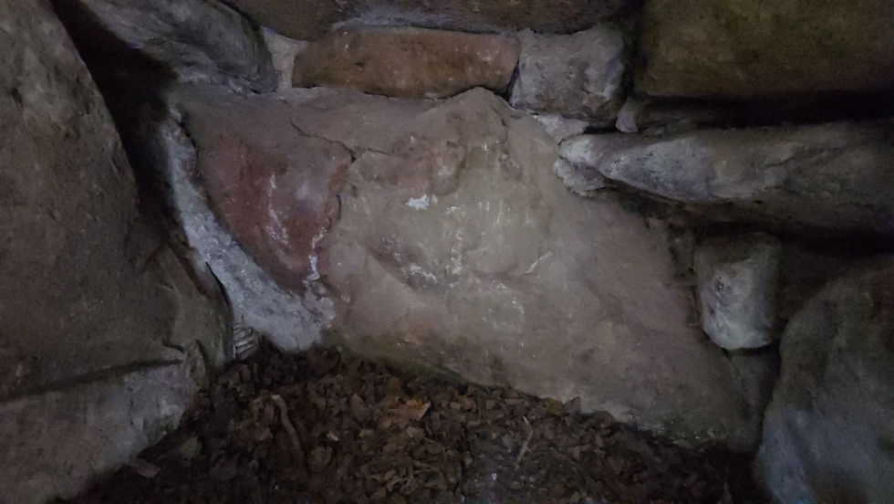
That is particularly important in the eastern chamber on the cup marked side. No human assemblage assigned specifically to it is identified in the surviving material discussed by the 2007 reassessment. This leaves its original contents uncertain. It does not establish that the chamber was empty or reserved for a different purpose, although differences in the arrangement and treatment of its stones remain worth investigating.
Leaving reverses the encounter. The passage directs the body back towards the opening, from the enclosed interior towards the landscape beyond. Those entering move broadly north-north-west; those emerging face south-south-east. The axis is therefore more than a line drawn through a mound. It is a direction enacted by the body, connecting an outside gathering place, a restricted interior and the world into which people returned.
Reading the Stones
Inside Wayland’s Smithy, the stones deserve more than a structural glance. Their faces, edges and hollows make each chamber feel different. I noticed this most strongly in the eastern chamber, where several inner surfaces appear unusually flat and regular. This is not simply a modern impression created by a convenient photograph. In Long Barrows (1925), O. G. S. Crawford quoted C. R. Peers’s observation that some stones, particularly on the inner faces of the eastern chamber, had been carefully worked to a true face. Were naturally smooth slabs sought out and selected? Were some faces improved by human labour? Or did the builders work with what the stones offered them, enhancing certain surfaces where it mattered? Whatever the answer, the eastern chamber seems to have been made with particular attention to its inner faces.
This is where the Stone Temple Gardening question begins. I do not think prehistoric builders chose stone only for strength, size and availability. A naturally suggestive form can acquire presence without being carved. Selection, positioning, touch acoustics and light may be enough to make it matter. In the eastern chamber, the flat surfaces may have created a more controlled visual setting in which distinctive natural forms were easier to notice, or perhaps easier to enhance.
As we have already noted at the northern entrance to the central passage, a substantial capstone offers one example. From the front, its irregular end can be read as an animal-like head. This is not a separate little lintel laid on top of the structure. The form belongs to the end of a large architectural slab.

The eastern chamber raises a larger possibility. It may not have been simply a second burial compartment, repeated for architectural symmetry. The surviving archive places human remains in the western and terminal chambers, while none is presently assigned to the eastern chamber. That does not prove the eastern chamber was always free of the dead. The tomb was disturbed before excavation and much of the early bone archive has been lost. But the surviving pattern is still striking enough to ask why the two lateral chambers may have offered different encounters.
My own working thought is that the eastern chamber may have been a space shaped for something other than the burial of bodies: a place of ritual encounter, perhaps, in which altered stone surfaces, cup-shaped hollows and natural animal-like forms created a different atmosphere. Were any of those forms coloured or otherwise enhanced? There is no pigment evidence from Wayland’s Smithy, so that must remain an open possibility rather than a claim. Yet painted or marked surfaces would make particular sense on the unusually flat faces.
The western chamber, by contrast, belongs more securely to the mortuary side of the monument. Its westward direction may also have held associations of setting, ending and the dead. I am not suggesting a crude prehistoric code in which west simply meant death and east meant life. But there is a genuine contrast worth following: documented human remains to the west, an eastern chamber with unusually treated inner faces and, perhaps, a different kind of experience waiting to be recovered from the stones.
The Inherited Line
Through these changes in material, scale and access, one feature remained remarkably consistent. Whittle, Bayliss and Wysocki explicitly describe Wayland’s Smithy II as following the same south-south-east to north-north-west alignment as the earlier monument beneath it. The mortuary structure also belongs to this broad directional arrangement. The survival of the line is an archaeological observation, not something that depends on an astronomical explanation.
With Hedley’s help, I repeatedly measured the surviving passage and chamber towards the south-south-east. Our working reconstruction of the monument’s axis is approximately 162°, with its reciprocal direction at 342°. I have spent considerable thought and research into what this inherited orientation might mean.
What interests me first is not the precision of a distant target, but the persistence of direction. The builders could change an accessible mortuary structure into a closed mound, then surround it with a much larger chambered monument, while continuing to work within essentially the same orientation. Direction appears to have been part of what they remembered here, suggesting a cultural meaning.
“Sacred line” is my poetic name for that continuity, not a claim that a compass can recover a belief. The line may have followed an existing arrangement because of practical constraints, remembered significance, relationships with the surrounding land, or attention to the sky. These possibilities can be investigated rather than merely listed.
`

The Line and the Sky
The inherited SSE–NNW direction of Wayland’s Smithy does not, by itself, prove an astronomical purpose. It is first an archaeological fact: a line was established at the earlier mortuary place, retained in Wayland’s Smithy I and then carried into the larger stone monument. That continuity is significant before we raise our eyes to the sky.
One myth needs dealing with first. Wayland's Smithy is not facing the midwinter-solstice sunrise alignment sometimes claimed for the tomb. The geometry does not support it. A winter sunrise lies far to the south-east of the monument’s approximately 162° axis. Whatever the direction meant, it cannot responsibly be explained by repeating a familiar solstitial story.
A terrestrial relationship remains possible. Tower Hill lies to the south-south-east in the wider landscape, and its prehistoric activity makes it a reasonable place to investigate. But it should not be presented as a demonstrated target. Its mapped bearing does not produce a neat continuation of the monument’s axis, and the modern trees prevent any simple judgement about what could have been seen from the façade or chamber in the Neolithic. For now, Tower Hill is a landscape possibility, not an established orientation focus.
The celestial question is more complex still. Ilaria Cristofaro has proposed that Wayland’s Smithy may belong to a changing Neolithic skyscape involving Deneb and Cygnus to the north-west, Crux and Centaurus low in the southern sky, and the winter Milky Way. This is not a proposal about one star sitting permanently at the end of the passage. It is about a night sky in motion.
In the fourth and third millennia BC, precession meant that the stars we now call Crux, or the Southern Cross, were still visible from southern Britain, although very low above the southern horizon. That alone makes the prehistoric sky unfamiliar to us. The Cross has since slipped below the British horizon, while Cygnus and Deneb remain familiar features of the northern sky. Modern constellation names are useful labels for us, of course, not evidence that Neolithic people saw a cross or a swan in the same way.
Cristofaro’s wider Crux–Centaurus work asks us to imagine what happened during a winter night, rather than freezing the sky in a single astronomical diagram. As the Earth turned, the bright band of the Milky Way changed its relationship with the horizon. It could seem to fall towards the western horizon, flatten and spread around the visible world, then rise again in the east. The low southern stars of Crux and Centaurus marked a pivot in that dramatic turning of the galactic band. In this model, the sky did not merely contain landmarks. It performed a slow, immense rotation above the land.
At Wayland’s Smithy, the proposal is that the monument’s inherited SSE–NNW direction may have placed its architecture within that larger pattern. The south-south-east line leads towards the part of the horizon where Crux–Centaurus could once have appeared; the north-north-west points towards the northern Milky Way around Deneb and Cygnus. The passage is therefore potentially more than a route through a mound. It may have established an earthly counterpart to a celestial line, joining opposite parts of a sky whose great luminous river appeared to turn around the horizon.
Nicholas Mann’s work at Avebury provides one important comparative context for this kind of interpretation. John Grigsby pushes the argument further, using comparative Indo-European mythology to explore what the Milky Way might have meant in a Neolithic religious imagination. His thesis identifies repeated orientations towards stars within the Milky Way, particularly Crux and Cassiopeia, at a range of British ceremonial sites. He argues that these alignments often work with rivers, hills, mounds and entrances, creating a pattern in which landscape and sky are made to answer one another.
Grigsby’s larger interpretation is deliberately ambitious. Drawing on later Irish, Egyptian and wider Indo-European traditions, he proposes that the Milky Way may have been imagined as a celestial river or the body of a great bovine mother figure: in Irish tradition, the Path of the White Cow. Within this model, the dead do not simply disappear into a tomb. Their spirits travel along the bright galactic river, passing through the body of a cosmic mother towards renewal or rebirth among the stars.
This is where the idea of a soul’s journey enters the discussion. Grigsby suggests that a tomb or ceremonial entrance might have been understood as a threshold between earthly and celestial realms: a place through which souls could enter the Milky Way, or from which they might return in a cycle of birth and rebirth. The passage becomes, in his language, something like a stargate. That is not evidence that anyone at Wayland’s Smithy held this precise belief. It is a comparative hypothesis, built by reading much later myth alongside astronomical and archaeological patterns. The distance between those sources and a Neolithic long barrow must remain visible.
Yet the hypothesis does give us a more substantial question to ask of Wayland’s Smithy. This was a monument repeatedly associated with the dead, built on an inherited line, entered through a narrow passage and opened again towards a sky that was then far less obstructed than it is today. If its direction had a celestial dimension, the astronomy would not have been an abstract calculation. It would have joined bodily movement, the burial mound, the open horizon and the visible turning of the Milky Way into a single act of encounter.
That is a possibility, not a recovered Neolithic explanation. The secure fact remains the inherited direction. Cristofaro, Mann and Grigsby offer different ways of asking why that direction might have mattered, but none removes the need for caution. Their value is not that they solve Wayland’s Smithy. It is that they restore the sky to a monument from which modern trees have taken so much of the horizon.
Conclusion: Wayland’s Smithy. A Neolithic Ritual Place Made Again and Again

Wayland’s Smithy is often presented as a single tomb, a fixed object from the deep past. Its archaeology tells a more restless story. First there was an accessible mortuary place of timber and stone, where bodies and bones were brought into a carefully bounded space. Then came a small mound, closing the earlier deposits beneath earth and chalk. Finally, perhaps within the memory of people who knew the first mound, a much larger long barrow created a new stone interior and new chambers in which the living could again encounter the dead.
Each rebuilding altered the experience of the place. Access became enclosure; enclosure became a new, more monumental form of access. Yet the builders did not abandon the site or erase its broad orientation. They returned to it, extended it and gave it new architectural life. That continuity is the real meaning of the sacred line, before we attach it to any particular hill, star or celestial event.
The modern visitor meets a further remaking. The chambers and façade have been excavated and restored; the mound has been made readable again; the beeches have enclosed a monument that once stood more openly in its downland setting. Even so, the architecture still does its work. It gathers us before the façade, narrows us into the passage, turns us among the chambers and sends us back out towards the southern landscape.
Walking there with Hedley on that warm late-summer day, I was struck by how much Wayland’s Smithy asks of the imagination, but also by how much is physically present. Its history is written in changing materials, buried bones, inherited direction, worked ground and monumental scale. We cannot recover every meaning, but we can recognise a place repeatedly made to matter.
Part Two will follow the line beyond the façade: towards the landscape, Tower Hill and the possibility that the changing Neolithic sky also formed part of Wayland’s Smithy’s enduring design.
Look closely.
Think independently.
Keep the wonder.
Stone Temple Gardening
Dr Alexander Peach September 2026
Stone Temple Gardening is built through fieldwork: walking, filming, photographing and testing prehistoric landscapes on the ground. If this work interests you, you can support future site visits and research here.
Bibliography
Atkinson, R.J.C. (1965) ‘Wayland’s Smithy’, Antiquity, 39(154), pp. 126–133. doi: 10.1017/S0003598X00031653.
Atkinson and S. Piggott’, Proceedings of the Prehistoric Society, 57, pp. 61–101.
Crawford, O.G.S. (1925) The Long Barrows of the Cotswolds: A Description of Long Barrows, Stone Circles and Other Megalithic Remains in the Area Covered by Sheet 8 of the Quarter-Inch Map of England. Gloucester: John Bellows.
Cristofaro, I. (2015) ‘Skyscape archaeology at the Neolithic long barrow of Wayland’s Smithy (Oxfordshire)’, working paper. Available at: https://doi.org/10.2139/ssrn.5682462 (Accessed: 13 September 2026).
Darvill, T. (2004) Long Barrows of the Cotswolds and Surrounding Areas. Stroud: Tempus Publishing.
Grigsby, J.M. (2019) Skyscapes, Landscapes, and the Drama of Proto-Indo-European Myth. PhD thesis. Bournemouth University. Available at: https://eprints.bournemouth.ac.uk/32226/ (Accessed: 13 September 2026).
Historic England (n.d.) ‘Wayland’s Smithy chambered long barrow, including an earlier barrow and Iron Age and Roman boundary ditches, Ashbury, 1008409’. National Heritage List for England. Available at: https://historicengland.org.uk/listing/the-list/list-entry/1008409 (Accessed: 13 September 2026).
Mann, N.R. (2011) Avebury Cosmos: The Neolithic World of Avebury Henge, Silbury Hill, West Kennet Long Barrow, the Sanctuary and the Longstones Cove. Alresford: Moon Books.
Peers, C.R. and Smith, R.A. (1921) ‘Wayland’s Smithy, Berkshire’, The Antiquaries Journal, 1(3), pp. 183–198.
Taylor, C. (1979) Roads and Tracks of Britain. London: J.M. Dent & Sons.
Whittle, A. (1991) ‘Wayland’s Smithy, Oxfordshire: Excavations at the Neolithic tomb in 1962–63 by R.J.C.
Whittle, A., Bayliss, A. and Wysocki, M. (2007) ‘Once in a lifetime: the date of the Wayland’s Smithy long barrow’, Cambridge Archaeological Journal, 17(S1), pp. 103–121. doi: 10.1017/S0959774307000194.
Fieldwork note
Descriptions of the modern approach, photographs, and compass readings are the author’s own field observations, made with Hedley Thorne.


Comments