Arbor Low Stone Circle: The Stonehenge of the North in the Peak District
- Mar 22
- 19 min read
Updated: May 5

Welcome to Stone Temple Gardening, where archaeology meets perception and ancient landscapes are explored through movement, memory and place. Here we dig deep into the soil of time to cultivate new understandings of the prehistoric past.
Arbor Low
You do not see Arbor Low from a distance. It reveals itself slowly, as the ground rises and the horizon begins to open. The land lifts you onto the limestone plateau, and only then does the monument emerge, set within a shallow basin, enclosed, deliberate. By the time you arrive, you are already inside its landscape. This is not accidental. The approach matters. The ground matters. And the monument sits exactly where these conditions resolve.
Arbor Low is often described as a henge monument, a stone circle set within an earthen enclosure.
But this description starts too late. It begins with the monument, when the experience of the place begins long before it.
My Method: Place First, Monument Second.
In recent decades archaeologists such as Christopher Tilley and Richard Bradley have argued that prehistoric monuments cannot be understood apart from the landscapes in which they stand. Paths, horizons, natural features and repeated human encounters with place all contributed to the meanings that monuments later formalised in earth and stone.
Ancient monuments in the landscape are not the beginning. They are the late harvest of a much older relationship with place. People moved through these landscapes, paused, returned, and slowly cultivated memory and layers of meaning there. What first drew them may have been something small — a distinctive horizon, a spring, a curious rock — a place where the first seed of meaning took root. Only later did monuments crystallise that cultivated relationship in earth and stone.
This is the method behind Stone Temple Gardening: to begin not with the monument alone, but with the landscape that first drew people in — its routes, horizons, landforms and settings — and to patiently tend the enduring question: why is this here?
And that is a question that leads us naturally to one of the most remarkable prehistoric landscapes in Britain. Today our path takes us to Arbor Low, a monument that stone circle expert Aubrey Burl once called “the Stonehenge of the North”.
Why is Arbor Low Stone Circle the Stonehenge of the North?
Arbor Low is often compared to Stonehenge. The comparison is not merely poetic. In scale and architectural ambition the monument stands among the most impressive prehistoric ceremonial structures in Britain.
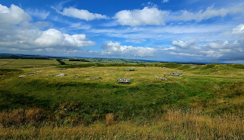
The monument at Arbor Low forms a near circular henge roughly 90 metres across, enclosed by a substantial earthen bank and internal ditch. Within this earthwork lies a ring of 50 or so limestone slabs and fragments, the remains of a stone circle about 25 metres in diameter. Today the stones lie scattered across the grass, their grey surfaces weathered and gnarled by centuries of exposure, but they were almost certainly once raised upright to form a dramatic ring within the enclosure. In the center is a remnamt of a structure or cove formed of now recumbent stones.
In size the henge itself compares surprisingly closely with the earthwork at Stonehenge, whose enclosure measures around 110 metres across. Yet architecturally Arbor Low may actually resemble Avebury more closely. Like Avebury it is a true henge monument, defined by a substantial outer bank and internal ditch surrounding the stones. The bank at Arbor Low remains up to two or three metres high, giving the monument a strong sense of enclosure within the open limestone plateau.
Despite these similarities the character of the site is very different from the great monuments of southern England. Where Stonehenge rises as a skyline monument on the chalk plains, Arbor Low lies within a shallow natural bowl of land high on the Derbyshire uplands. Like Avebury, the monument does not immediately reveal itself from afar. Instead it waits quietly within its earthwork until the visitor crosses the bank and the stones are suddenly revealed inside. It is one of the most significant ritual complexes in England.

Exploring the ceremonial landscape of Arbor Low and Gib Hill in the Peak District.
To gain new insights into the landscape and monuments surrounding Arbor Low we must first approach this place as its builders once did and attempt to recreate what they may have seen in the surrounding country. Their ascent from the valleys and crossings of the open limestone plateau brought them first past the great long barrow at Gib Hill, before continuing on to the enclosing earthwork at Arbor Low and what lies hidden within. From there the eye moves outward again to the surrounding horizons.
Archaeology is increasingly recognising that such journeys were not incidental. At many ancient sites the movement through the landscape appears to have been as important as the monuments themselves, which served as waypoints, markers of arrival, and focal points for ritual attention.
Archaeological investigation shows that the monuments at Arbor Low developed over several phases of prehistoric activity.

The earliest monument is the long barrow at Gib Hill, constructed during the early Neolithic in the fourth millennium BC.

Several centuries later, around 3000 BC, the great circular henge earthwork at Arbor Low was constructed. Only afterwards were the stones erected within the enclosure, forming the stone circle that occupies the interior today. Excavations have recovered stone tools, pottery fragments and other traces of activity suggesting that the monument served as an important ceremonial gathering place.
The landscape continued to be used into the Bronze Age, when burial mounds were added around the site and even against the bank of the henge itself.
The Landscape of Arbor Low and The White Peak Plateau

Arbor Low stands high on the limestone uplands of the Derbyshire White Peak in the heart of England, set within a broad basin, a place where distant vistas open across the plateau. To be here is to stand suspended between sky, earth and horizon. The upland is clothed in green pasture where the thin soil is drawn over pale rock that breaks through the sward in scattered, broken patches. In summer buzzards wheel above, flowers nod their heads below as cattle crop the turf close, their breathy lowing drifting dreamily across the windswept fields.
Above them all the sky feels immense.

From the higher ground the prospect runs wide and uninterrupted. Clouds stream over the limestone country like a river of wool, herding rain and sunlight across the open fields. This is a land of wild horizons and uncluttered distance, a place that seems prepared for looking, feeling, gathering.
From this high arena the land falls toward several river systems below: the Wye, the Dove, and the Lathkill, whose valleys cut deep through the plateau. Ancient paths rising from these valleys would naturally converge on the upland before crossing the three watersheds near the site. Long before any monument was raised, this would already have been a place where movement brought people together.

In the language of landscape archaeology such locations become what the sociologist Anthony Giddens theorised as “locales”, settings where repeated human encounters give a place a foundational social meaning long before monuments appear. Over generations the acts of travelling, meeting, and gathering slowly shape how a place is understood. Only later do stones and earthworks formalise what people had already long recognised. Places were not empty backdrops, but environments layered with memory, story, and the traces of past encounters.
Arbor Low is one such place and the archaeological richness of this area is apparent.
At nearby Monyash and Taddington Moor, flint scatters and prehistoric remains show that people were already active in this region during the Neolithic period long before the site was first marked. In the centuries that followed the Neolithic founding long barrow, henge and stone circle, the surrounding ridges became the focus of Bronze Age burial activity. Surveys by archaeologists such as John Barnatt have shown that the plateau around Arbor Low contains one of the densest concentrations of prehistoric barrows in the Peak District. This long sequence of activity is mirrored at the monument itself, where later Bronze Age burial mounds were added to the earlier Neolithic landscape.

Journey and Arrival at Arbor Low
When prehistoric people approached the monuments of Arbor Low from the valleys below, their journey began, as it still does, in a very different environment.
Down in the Derbyshire Dales the land feels enclosed and sheltered. Streams wind along the valley bottoms beneath steep grassy slopes where ash and hawthorn cling to the rock like hoary hands gripping the weathered stone. In places the water spills over pale limestone ledges before slipping away toward the rivers of the Wye, Dove and the Lathkill.

These valleys have long provided natural routes through the Peak District. Paths follow the watercourses where the ground is easiest to travel and fresh water is always close at hand. Even today walkers still climb the dales along these streams before emerging onto the open uplands above.
One likely route starts in the Lathkill valley, climbing through the limestone gorge of Cales Dale before reaching the upland near the village of Monyash. The valley forms a natural corridor through the hills, and the ascent leads gradually onto the watershed plateau where the valley opens and the climb ends.
Recent archaeological work has confirmed that this valley route may have served as a prehistoric approach to the henge. This has led researchers to propose that the natural topography of Cales Dale may have been used as a processional route linking the River Lathkill with the ceremonial complex on the plateau. Water connected to monument is a constant theme in prehistory (I have written about this here).

As these ancient travellers climbed out of the enclosed dales into the open, they would have crossed a natural threshold in the land. From enclosure to expanse, and on this high watershed between valleys, the monument stood waiting for them, as it still does for us today.
The First Monument: Gib Hill

As travellers (or pilgrims) reached the upland during the Neolithic, the first monument they encountered in this landscape would be the long barrow of Gib Hill.
Rising from the pasture the barrow stands as the earliest known monument within the ceremonial complex. Today it appears as a broad rounded mound that lifts its head prominently above the surrounding fields. Yet this current visible form belongs to a later chapter in the mound’s history.
Excavation has shown that beneath the later Bronze Age mound lies the remains of a much earlier Neolithic long barrow, constructed in the fourth millennium BC when communities across Britain first began raising communal burial monuments. These elongated mounds were typically formed by piling earth and stone over burial deposits, sometimes containing the remains of several individuals placed within timber structures or stone-lined chambers before the mound was raised above them. (I have written several articles on long barrows, here, here, here and here)

Such monuments were more than tombs. They marked places where communities returned repeatedly to perform rituals, possibly to remember the dead, encourage fertility or reaffirm connections between people, ancestors and the land. Gib Hill therefore became the first monument to mark this landscape.
The barrow occupies a slight ridge within the shallow basin that holds Arbor Low. From this rise the ground falls gently away toward the later henge and circle. Centuries later the monument was reshaped when a new burial mound was raised over the earlier barrow. The hill visible today therefore conceals the earlier monument beneath it. The site preserves more than one moment in time, recording the actions of different communities who returned to this place across many generations, illustrating the culturally layered concept of locale. The two monuments hold hands together across time.

Moving Between the Monuments
The route continues along another feature, a slight earthwork that runs across the plateau between the two monuments. The dating of this raised ditched earthwork is uncertain, but it is certainly ancient; now softened by centuries of weather and grazing, forming a subtle avenue in the grass. It does not impose itself on the landscape but gently shapes movement across it, drawing the traveller onward toward the henge. Passing along this line the long barrow slowly recedes behind while the great enclosure ahead gathers presence.
Geophysical survey has shown that the earthwork linking Arbor Low and Gib Hill does not form a straight avenue, but a segmented and curving feature, parts of which run broadly east–west and do not directly target the mound. Rather than defining a fixed alignment, the feature appears to guide movement across the plateau, shifting its course as it traverses the ground and drawing the traveller into the wider landscape beyond the henge. Its trajectory is not that of a line aimed at a single point, but of a path that unfolds through space.

Within this broader setting, the winter solstice sunrise rises in the south-eastern sky, close to the same general sector of horizon occupied by Gib Hill, though not directly over it. The earthwork does not point toward the sunrise, nor toward the mound, yet all three are gathered within the same southern arc of the landscape. What emerges is not a single axis, but a shared field of orientation in which movement, monument and seasonal light coincide.
The earthwork binds Gib Hill and Arbor Low together, transforming the walk across open ground into a quiet procession where arrival begins long before the stones come into view.
The effect seems deliberate. The mound remains visible behind while the henge bank lies quietly ahead on the skyline, the two connected not by a straight line, but by a curving path of earth that holds them within the same field of movement. In this relationship the earlier monument continues to anchor ancestral presence within the landscape as the great circular enclosure rises beyond it. Together they create a quiet choreography across the plateau, a structuring of mound, earthwork and enclosure through which the traveller moves, held within a dialogue of time, memory and place.
Within this wider field the horizon itself participates. Over the course of the year the rising sun moves along a broad arc of the eastern sky, from the north-east in summer to the south-east in winter. From this approach, Gib Hill lies just beyond that arc, slightly to the south of the winter solstice sunrise. The sun does not rise over the mound, nor does the earthwork define any precise alignment. Yet at midwinter the returning light appears closest to it, occupying the same stretch of horizon before shifting away again as the seasons turn.
It would be easy to overstate this relationship as intentional alignment. The evidence does not support such precision. What can be observed instead is a looser but persistent correspondence: the curving earthwork, the earlier mound and the path of the rising sun all inhabit the same sector of the landscape. The significance, if there is one, lies not in a fixed line, but in a shared orientation, where movement, monument and seasonal light are experienced together within a common horizon field - one that perhaps helps answer, in part, why this place drew attention in the first place.

As you walk toward the monument the ground begins to rise until the great earthen bank lifts above you. Here the body is stopped. Standing beside the bank there is still nothing to see of what lies within, the interior completely hidden behind the enclosing wall of earth. The movement that has carried you across the plateau now pauses at the threshold. Only by turning toward the entrance does the route open, and even here the passage is slightly offset so that the centre of the monument remains concealed. The design quietly guides movement across the bank and into the enclosure, shaping the moment of entry.
To someone approaching without knowing what lies inside, the effect would be striking.
Entry to the Henge
Turning right, you pass to the shoulder of the rampart, then step left and down into the enclosure.
Like all true henges, the monument is defined not only by its great bank but by a ditch that runs just inside it. Today the ditch is shallow and easily overlooked beneath the turf, but when first dug it would have formed a clear inner boundary separating the interior from the surrounding plateau. The earthwork itself was likely constructed before the stones were raised, creating a circular arena into which the later builders set the stone circle.
Suddenly the stone circle and henge reveals itself.

The effect is theatrical: the long procession from valley to plateau, from barrow to henge, resolving in an instant within the ritual heart of the temple.
The entire sequence seems designed to manipulate the senses and stir the emotions, guiding the body through approach, concealment and pause before the moment of ritual revelation.
Once proud uprights, the weathered grey limestone slabs now lie toppled like a giant’s deck of cards—over fifty broad, heavy stones and jagged fragments strewn across the grassy interior. Some stretch long and blade-
like where the stone has cleaved along its natural bedding planes; others squat massive and rounded, their pale surfaces etched by millennia of wind and rain. Seen from within the enclosure they resemble fossilised clouds fallen to earth, gnarled forms resting beneath a dreaming sky.

For a moment the body forgets the journey that brought it here. Movement falls away as the eye begins to wander across the fallen stones and their strange forms. Enclosed by the high curtain of earth, the effect is quietly powerful, and must once have been far more intense when the stones stood upright.
The circle itself is not perfectly round. Instead, the stones form a slightly flattened oval whose long axis runs roughly north-west to south-east. This orientation broadly echoes the line of the two entrances through the henge bank and the rising of the midsummer sun. Within the interior lies one of the monument’s most intriguing features: the remains of a small cove, originally formed by a tight grouping of larger stones that would once have stood upright, creating a partial chamber open toward the south-east. Such coves are rare within British stone circles and may have marked a focal point for ritual activity within the enclosure.

The western side of the monument tells another story. Here the line of the bank is interrupted by a later Bronze Age round barrow that rises against the henge earthwork. Built many centuries after the circle itself, the mound distorts the original shape of the enclosure, pushing into the interior and altering the symmetry of the monument. Its presence hints that Arbor Low remained an important ceremonial place long after the Neolithic builders raised the stones, part of a landscape where successive generations returned to build, remember and reshape the ground around them.
Sky and Horizon

The architecture of Arbor Low does not only organise movement across the landscape. It also frames the sky.
The oval formed by the stones and the position of the entrances emphasise a north-west to south-east axis through the monument. Looking outward from the centre of the circle along this line, the view opens toward the distant horizon of the Peak District.
Researchers studying the monument’s orientation, including Alexander Thom and Clive Ruggles, have noted that this axis broadly follows the direction of the midsummer sunset. Around the time of the summer solstice the sun sinks slowly toward the north-west horizon, its light spreading across the far plateau before slipping beneath the distant hills.
The significance of this relationship may lie less in a precise point on the skyline than in the character of the horizon itself. Unlike monuments such as Stonehenge, which focus attention on a narrow alignment, Arbor Low opens toward a wide distant skyline across which the sun and moon travel over the course of days, seasons and years.
In such a setting the movements of the heavens unfold gradually. Evening after evening the setting sun slides along the edge of the plateau before disappearing below the land. The horizon becomes a natural screen against which these slow celestial rhythms can be watched.
---------------------------------------------------------------------------------------------------------------------------------------------------
Comparative Note: West Kennet and Orientation Without Alignment
At West Kennet Long Barrow at the Avebury ceremonial complex, the entrance faces broadly east, and around the equinox the rising sun can illuminate the chamber in a striking display. This has often been described as intentional alignment.
However, recent reassessment suggests a different explanation. The barrow’s axis lies several degrees away from exact equinox sunrise, creating a wide window in which light enters over a number of days. Across southern Britain, hundreds of long barrows show similar patterns, with orientations falling broadly within the arc of the rising sun rather than targeting specific solar events.
Studies of regional landscapes indicate that these orientations often follow the grain of ridges, valleys and viewsheds. In this context, the apparent solar effect at West Kennet is best understood not as precise astronomical design, but as the outcome of broader cultural preferences and topographic constraints. The sun, in effect, cooperates with an already meaningful direction. (e.g. Greaney 2021; Marshall 2021).
A similar pattern may be present at Arbor Low. Here, monument, movement and seasonal light occupy the same sector of the horizon without forming a fixed alignment. The significance lies not in precision, but in orientation: a shared directional field shaped first by landscape, and only secondarily intersected by the sky.
---------------------------------------------------------------------------------------------------------------------------------------------------
The basin in which Arbor Low sits strengthens this experience. The surrounding ground rises gently around the monument before falling away again toward the valleys beyond. From within the enclosure the viewer stands inside a soft amphitheatre of grass and earth where land and sky meet along a broad rim of distant hills, the bank of the henge framing the skyline like the edge of a great natural theatre.
Stone, earthwork, horizon and sky combine to form a single architectural composition.
Whether marking seasonal gatherings, ancestral memory or simply the meeting of land and sky, the monument binds these elements into a single place on the high limestone plateau.
Behind lies the ancestral mound of Gib Hill.
Ahead stretch the distant horizons of the White Peak.
Between them
stands the circle.
The Ceremonial Landscape of Arbor Low
Seen as a whole, Arbor Low is not simply a stone circle but the centre of a carefully composed ceremonial landscape.
The site stands where routes rising from the surrounding valleys meet on the high limestone plateau. Long before the first stones were raised, people were already moving through this place, gathering where paths converged and distant horizons opened wide. Over generations those encounters with land, sky and memory gave the place its meaning.
The monuments that survive today crystallise that relationship. First came the long barrow of Gib Hill, marking the presence of ancestors within the landscape. Centuries later the builders of the henge and stone circle created a new focus nearby. The earlier mound was not erased but incorporated into the spatial logic of the complex. Behind lies the ancestral monument; ahead stretches the distant horizon.
Between them the circle occupies the basin.
The journey through this landscape appears carefully structured. Travellers ascending from the valleys encounter the ancestral mound, cross the open plateau, and approach the enclosing earthwork of the henge. The bank halts the body and conceals the interior until the moment of entry, when the circle suddenly reveals itself within. Movement, concealment and revelation combine to create a strikingly theatrical sequence.
Within the enclosure the monument opens again toward the sky. The oval axis of the circle frames the wide north-west horizon where the midsummer sun sinks slowly beyond the hills. Rather than pointing to a single marker, the monument engages the distant skyline itself.
Across the wider landscape a similar pattern can be glimpsed. The curving earthwork, the earlier mound and the path of the rising sun do not converge on a single line, nor do they form a precise alignment. Instead they occupy the same broad sector of the horizon, a shared orientation that binds movement, monument and seasonal light into a common field of experience. The south-eastern entrance, though not precisely aligned, opens toward the same horizon zone in which the winter sun rises, complementing the north-western emphasis on midsummer sunset.
Arbor Low therefore binds earth, monument, horizon and sky into a single place on the high plateau.
And this returns us to the question that began our journey.
Why here?
Because here the land gathers paths, holds the presence of ancestors, and opens outward to the wide horizon of the Peak District — a place where movement, memory and the turning sky are brought into a shared orientation that perhaps helps explain why it was chosen, returned to, and ultimately monumentalised.
If you have the chance, come here yourself.
Walk the valleys.Climb the plateau.Pass the mound of Gib Hill and enter the henge.
Stand within the circle and watch the horizon.
The memory of this place is still held, quietly, within the landscape.
Dr Alexander Peach,
Bandung, Java,
March 2026

If you enjoy this exploration of the prehistoric landscape, please consider liking, sharing, or leaving a comment. You can also subscribe to receive new Stone Temple Gardening posts as they are published.
Stone Temple Gardening is built through fieldwork: walking, filming, photographing and testing prehistoric landscapes on the ground. If this work interests you, you can support future site visits and research here.
Bibliography
Barnatt, J. (1989) Stone Circles of the Peak District. Sheffield: Sheffield Archaeological Monographs.
Barnatt, J. (1990) The Henges, Stone Circles and Ring Cairns of the Peak District. Sheffield: Sheffield Archaeological Monographs.
Barnatt, J. and Edmonds, M. (2002) Stone Landscapes: Settlement and Monument Construction in Neolithic and Bronze Age Britain. London: Routledge.
Bradley, R. (1998) The Significance of Monuments: On the Shaping of Human Experience in Neolithic and Bronze Age Europe. London: Routledge.
Bradley, R. (2000) An Archaeology of Natural Places. London: Routledge.
Bradley, R. (2024) ‘Geoglyphs, Petroglyphs and Megaliths’, in Díaz-Guardamino, M., García Sanjuán, L. and Wheatley, D. (eds.) Megalithic Societies: Old Questions, New Narratives. Oxford: Archaeopress.
Burl, A. (2000) The Stone Circles of Britain, Ireland and Brittany. New Haven: Yale University Press.
Greaney, S. (2021) Monuments of the Avebury Landscape. PhD thesis. Cardiff University.
Harding, J. (2003) Henge Monuments of the British Isles. Stroud: Tempus.
Heath, I. P., Cheetham, P. and Shaw, L. (2013) Geophysical Survey Report, Arbor Low Environs Project: Gib Hill Barrow, Derbyshire. English Heritage.
Marshall, A. (2021) Orientation of Prehistoric Monuments in Britain: A Reassessment. Oxford: Archaeopress.
Ruggles, C. (1999) Astronomy in Prehistoric Britain and Ireland. New Haven: Yale University Press.
Tilley, C. (1994) A Phenomenology of Landscape: Places, Paths and Monuments. Oxford: Berg.
Arbor Low
Arbor Low stone circle
Arbor Low henge
Stonehenge of the North
Gib Hill long barrow
Peak District archaeology
Neolithic Britain
prehistoric ceremonial landscapes
Derbyshire stone circles
archaic ritual landscapes
Neolithic henges
stone circles UK
archaeology of the Peak District
ancient monuments Derbyshire
midsummer sunset alignment
ancient astronomy Britain
prehistoric pilgrimage routes
ritual landscapes Britain
Stone Temple Gardening
Peak District stone circle
Arbor Low Derbyshire


Hi Alex, I really enjoyed your description of the landscape around Arbor Low. I have studied it quite closely for my PhD research into prehistoric avenues. But I am very sceptical about the idea that the embankment is an integral part of an ancient ritual landscape.
Personally, I do not find that the earthwork “links” the monument with Gib Hill at all, either physically or visually. Standing on top of the mound at Gib Hill, it is difficult to imagine making a procession along the major detour of the “avenue” earthwork rather than more directly to the main entrance of the henge. Unless, of course, we have an orientation of the long barrow of Gib Hill that might point us…